Sodom
Mountain Resort
Southwick,
MA
1969-?
| NELSAP first heard of this area
from Kevin Thomas. Sodom Mountain was a brief, rope
tow ski area founded by Arthur Lafreniere, an excavation contractor, in 1969.
According to a Dec 13, 1969 article in the Berkshire Eagle, the area opened that
year with just a rope tow, but there were big plans - including a chairlift, a
T-bar, and potentially more lifts to be installed in early 1970's. When all is
said and done, the area was to have a vertical of 900'. However, this would
never transpire. The area maxed out at 120' of vertical with several trails and
one single rope tow, about 800' in length.
There are virtually no other references to this
area...so it can only be surmised that it did not last long into the 1970's.
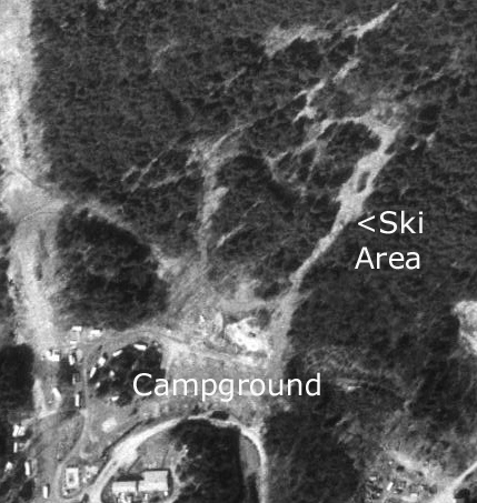
To the right is an aerial view of the ski area
in 1997. Karl Wolfe helped identify that this was the location of the ski area,
and not a similar complex next door that is part of a farm and was not a ski
area. You can see that there were several trails, with the rope tow likely
located on the right. The natural gas line is on the left and had been skied on
in the 2000's (not lift served). |
|
Jeff Kellogg
briefly worked here: Sodom Mountain Ski area, was operated at the location of what is now Sodom
Mountain
Campground, approximately 1/2 mile south of route 57 on South Loomis Street in Southwick. At the time it was operated by Art Lafreniere; I have no
knowledge of who owns the campground now. I spent one season on the ski patrol there after the closing of Southwick Ski Resort, but their
level of business was so low that I did not return the following year.
Mike Broggi: I use to camp there with my family in the 70's. There was a campground there with many camp site's and a lodge. Being a teenager at the time and loved to ski my friends and i use to hike the Mt
every time we camped there. There was 1 main area that led to the parking lot. It was a very steep maybe 400 slope that ended in the parking lot of the campground. Above this area up the mountain it was a much
gradual incline that led to a central peak. There where several narrow trails that spread out from the peak that all converged together at the top of the steep ending. I never
remember this other area it may have been there but never explored it.
Matt Cavallo: I
camped out there for many years and hiked the trails that were used for logging
way back then. While walking for about 1/4 of a mile into the trail, there is a
split in the trail. Take a left, then while heading up the slight hill on the
trail, you would find an opening of the top of a banked dirtmound on the right.
That is where there was a ski trail entrance. It was rather steep, a few hundred
feet long. Following it up you can still make out the clear lift line or trail,
then at the top there was a clearing and you can see the old truck chassis and
the rims that spun the rope/cable. The rims still spin too! Also, if you pass
the entrance to that ski trail and go about 15ft farther up, on the right there
is a large rock area and far into the rock area is a lift pole with a rim on it.
Very cool!
Last updated: December 21,
2013
Head
back to Lost Massachusetts Ski Areas
Head
back to the Main Page