Indian
Mound Ski Area
Newton, NH
1970's-Likely Closed Before 1978.
Indian Mound was a small, rope tow area that
operated in the town of Newton, most likely during the 1970's. The area was
closed before 1978, according to R. Berthel. It operated with
a wide slope, and a few woods trails. Lots of details can be found by reading
various visitor's commentaries below.
Betsy McDonough and I visited this area in 2000. We
basically just looked at it from Thornell Road. Not too much to see: a wide open
slope mainly. However, we did see what looked to be a small base lodge which is
only 20ft or so off the main road, check out the overhead pic below to see it.
This area is on private property and we would recommend that you view the area
only from Thornell Road, and don't trespass.
|
Steve
Estabrook, first told us about his ski
area: "There was a
ski area in Newton NH on Thornell Road called Indian mound ski area. It is
closed now but the poles from the rope tow stil remain."
Alex Speidel: Yes, there was a ski area off of
Thornell Rd. in Newton, NH (on the left side of the road heading west from
N.H. Rte. 108). You can see
it on old USGS maps (from the '60s and '70s). I believe that the Timberlane High
Ski Club went there in the 1970's on their trips. I couldn't believe that there was
a ski area there, but it's true. Your web site is very interesting; I
thought I was the only person interested in abandoned ski areas. It's too bad that small,
inexpensive areas
are disappearing.
Randy Percival
gave us the exact Lat/Lon of the area:
42
degrees, 51 minutes, 44 seconds North
71 degrees, 02 minutes, 53 seconds West |
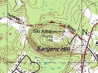
A view of
the area on a topo map, 1988. Thanks to Randy
Percival for giving us this
link.
|
|
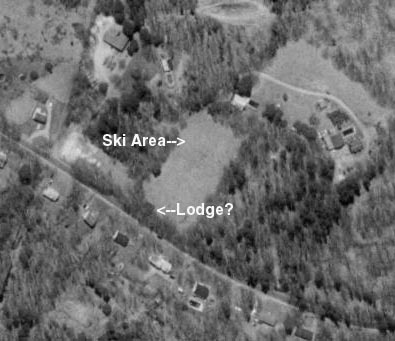
A
view of the area from above.
What is most likely the lodge has
been annotated.
As you can see, the area was fairly simple. It is
likely that some woods trails were located in the woods to the right of
the slope.
|
Brad Miller: I
have information on the Indian Mound Ski Area, in NH: In examining a 1972
USGS quadrangle topographic map (Haverhill, MA/NH; 1:25,000 scale), the
former Indian Mound Ski Area is clearly indicated. It is located off Route
108, on Thornell Road, about 0.75 miles south of Newton, NH, and several
hundred yards west of Sargent Corners, on the northeast side of Sargent
Hill. There appears to be only one lift at that time. An unimproved access
road leaves Thornell Road to a facility or lift building located high upon
the hillside, near the summit.
A later topographic map edition (1977)
indicates a similar layout; the 1985 topographic map does not show the
lift line or access road, but does depict an abandoned structure or
building on Thornell Road, and minor development (likely residential
homes) adjacent to the eastern limits of the former ski area. The building
near the summit was still indicated. Not surprisingly, a 1955 topographic
map only shows open land where the ski area was later located, which at
that time was probably just pasture or
orchards. |
Robert Zock:
Indian Mound is basically the front, sloping yard of the owner of the
property. It probably would be hard to find as a "ski area" on terra. I don't remember the name of the owner,
however in 1995 I bought their old grooming vehicle - a 1963 Skidoo Alpine - one
of the early ones. "Indian Mound"
can be made out on the fiberglass cowl of the machine. The owner was a machinist and built the
rope tow. The posts and sheaves
were still there when I visited.
The owner mentioned that they had some trails in the woods as
well.
Tom Cronin: I've lived
in Newton, NH for the past 13 years. I read the note from Steve Estabrook.
Yes, many parts of Indian Mound are still visible today. Some tow
components and the original base lodge is located about 300 yds west of the
intersection of Rte 108 and Thornell Road. The lodge is still in pretty
much it's original condition and until recently was used as a craft store.
The original parking area still exists and was used by the craft store
for customer parking.
Indian Mound had a slope on the Thornell
Road side of the hill and some trails on the back side. The hill is
visible from Rte 108 and just south of the intersection when the leaves are
down, you can still see where the trails led off the back side of the hill.
The Bakers (owners) still live on the property and were also the
builders of the ski area in the early 60's and craft store owners. I had heard
that due to liability costs, it proved eventually to be not profitable to
continue.Dave
Houghton: I think Ernst Foster taught lessons
here in the Mid sixties and then went on to head up the ski school in Bradford
before moving to Germany. Basically, my recollection is as follows: The front
side of Indian Mound was a single slope with a small (30 X 20 ish) base lodge.
The modern facilities consisted of an outhouse by the parking lot. The picture
you have on the site with Base Lodge? (aerial) is correct. The parking lot was
the area to the left level with the base lodge. The front slope was easy skiing
and had a rope tow running along the right side as you look up the hill. There
were speakers on the tow poles and music would be playing (I can distinctly
remember, Those Were The Days by Judy Collins??). All the local kids skied here.
Vertical drop here could not have exceeded 100 feet.
Many times there were jumps built from snow. The lodge had a small counter to
the right as you entered and candy and sodas were available (I am sure there
were other items but for me it was Charlston Chews and Grape soda in glass
bottles). There was a wood stove I think in the center where you would dry out
those nasty ski gloves made of some kind of white/grey leatherish material that
were always worn and soaked from the tow. Three pair of socks were the norm over
the lace up boots and front latch bear trap bindings. Later, in the late
60's we got buckle boots and step in bindings.
The back side of Indian Mound was where the brave went.
This was black diamond action for us as small kids. There was a second rope tow
that came up somewhere beyond the front slope tow but the rope went
perpendicular to the front slope going down to the left and back if you were
looking from the top of the front slope. It was very flat a the very top, there
were a number of ways to get down the back but it has become somewhat hazy to
me. I know that there were routes through the woods that switchbacked a bit (I
am talking about trails about eight feet wide at best) and then opened up onto a
steeper slope about half way down or less. I seem to remember a way to get back
to the parking lot side this way (traverse) or the "dreaded" back rope tow. As a
chid age 6-10 rope tows could be a challenge due to the weight but this tow had
major size bumps in it within the wood section and was fairly narrow for most of
it's distance. If you fell you screwed everyone up. We used to pray that it
would not stop. I can remember holding that rope with my hands dragging the
ground under it as I could no longer lift it. We would attempt to wait for
adults to get on in front of us. I have skied all over North America and British
Columbia but Indian Mound remains one of my fondest memories ever. I even stop
by once in a while and pull into the old parking area just for a peek.
|
|
Keith
Miller: I skied at Indian Mound after school in the late '70s. I
too attended Timberlane schools. No doubt I was in that ski club from
school. The "Bradford Bump" is the local hill of choice for our schoolkids
now. I used some old skis with spring bindings and leather dummy straps to
learn on. Which is worse, yardsaling and eating your strap attached ski or
chasing that runaway down to the warm up hut? "It's better to look good
than to feel good," I guess! :-) Maybe that's how the phrase was coined.
Went by there a month ago. Still looks the same!
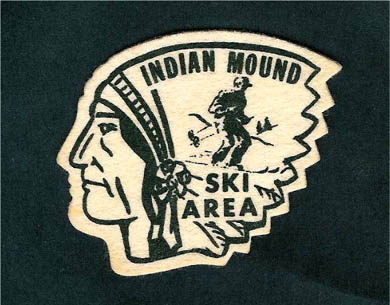
Here's a patch from
Keith.
|
Head back to Lost New Hampshire Ski
Areas
Head back to the Main Page