Chester Ski Area
The Pinnacle

Chester, VT
Just after WWII-1971, 1973-1989

History    By the Year    Pictures
History 

Chester Ski Area, also known as the Pinnacle, began in the late 1930's near the town center and near the Fullerton Inn. The area had a 1500' tow and a 1300' tow, at least until World War II. The Fullerton Inn and or the Chester Outing Club operated the area for much of its life. Other activities were present in town or at the area, including skating and tobogganing.

To the right is an overhead view, with a guess as to what the area looked like originally. One tow line estimate is listed, but I have no proof that that was where the lift is.

After World War II, the area apparently shrank, with the two long tows disappearing, and were replaced with a tow that had a length of 600 feet to 800 feet (guidebooks kept changing this). The area likely moved down the hill a little bit from the original area. The vertical was about 150', and skiing was done mostly on a wide open slope.

To the left is a map of the area during the rest of its existence until its closing.


Chester ski area operated until 1971, then closed for a few years, then reopened from 1973 to 1989. Much of tow was removed at some point in the 1990's.

To the right is a view of the ski area during the 1950's, courtesy Laurie P. Notice that a ski jump is visible at the top of the hill. The tow is hard to make out on here and could be anywhere.


An old map of Chester. Note the Pinnacle on the left, with a ski jump visible on it.
Tom Hildreth provides the following two photos of the ski area from January 29, 1984. This was five years before the ski area closed. As you can see, this was a classic community ski slope. Click on the photo for the larger version.

A view of the lower slopes and the town of Chester. Click on the photo for the larger version.

By the Year

Year Lifts Trails Other Info Source
1938-1939 1500' tow, beginner tow for kids unknown 55 meter jump, skating, tobogganing, snowshoeing, XC skiing. Fullerton Inn contact. Vermont Winter Sports
1939 1500 foot tow trails are well marked and cleared, open slopes for practicing, uphill bus service, log rest room accommodations and first aid stations in the vicinity. Ski Trails in The East and How to Find Them
1941-1942 Two tows Excellent slopes for beginners and intermediates 50 meter jump, tobogganing, snowshoeing, skating. Contact - Fullerton Inn. Vermont Winter Sports
1942 1500' and 1300' tow open slope XC skiing, 55 meter jump, night skiing Complete Skier's Guide
1947-1948 1500' tow, 1300' tow (lighted) Open slopes Contact Fullerton Inn for more info, skating rink Skier's Guide To New England
Late 1940's 700' tow 1/4-3/4 mile runs, 150' drop
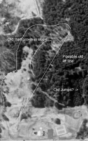
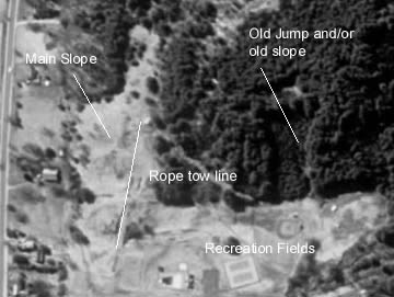
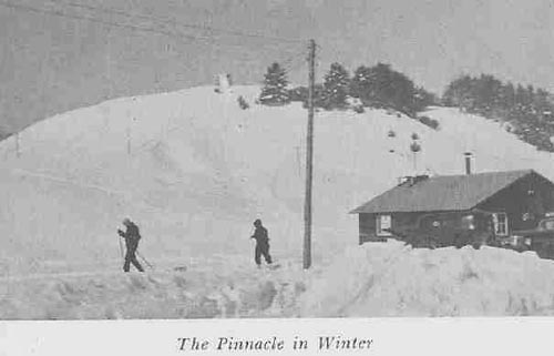
 The Chester Outing Club maintains a 700' tow with a 150' rise, and several returning ski runs ranging from 1/4 to 3/4 miles, a skating rink, a toboggan slide, a ski jump and some corking marked ski trails from 1 mile to 10 miles in length. These facilities are laid out for the enjoyment of the amateur and not for the professional. The sport is not commercialized in Chester, there are no large crowds. We prefer to welcome small parties of people who wish to get out and really enjoy themselves in their own way rather than those desiring to witness a large expedition. A limited number of skis will be available. Chester Winter Sports Brochure
Early 50's 800' tow 1 expert, 1 beginner, 1 intermediate, 6 acres open slopes Contact Chester Inn for more info; shelter, food available "Vermont, a Winter Wonderland"
1958 Tow Unknown "A good area to practice" Vermont Life Article by Murray Hoyt
1969-1971 600' tow unknown N/A VT Tramway reports
1972 --- --- Area is not inspected, thus may have not have been open Same
1973-1989 600' tow unknown Area reopens in 1973, then closes in 1989 Same


Pictures

In 2000, Betsy McDonough and I found this area. The rope tow summit building was still standing, albeit vandalized. There is a skatepark at the bottom of the area.  However, trails are still clear and are free for the hiking, so check it out.

A view of the area from the bottom, October 2003, showing the skate park and cleared slope. Rope tow line is on the right of the slope. This pic and all the rest are from October 2003 and Laurie P.

The base of the area.
Looking down the slope from near the top of the tow.

Looking down the rope tow line.
Top building for the tow. Some machinery still exists within the building. There are no poles for the tow or base machinery left.

Start/stop switch.
Looking from inside the building, where the rope used to cycle through.

If you have more information on this area, just let us know.

Last updated: August 11, 2009

Head back to Lost Vermont Ski Areas

Head back to the Main Page