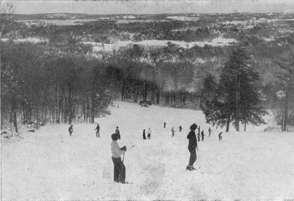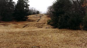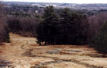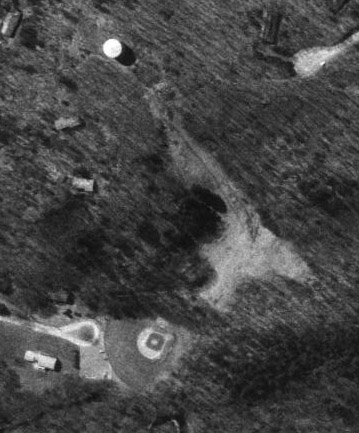
Aerial view of the ski area. It is still
maintained today. Vertical drop was 160', and the tow was about 700'
long.
Thanks to NELSAP reader Jed Diehl, we now know of this small ski area that operated in the town of Weston. Here's what Jed has to say about the ski area:
| "Cat Rock Hill Ski Area in Weston, Massachusetts, was run by the Town of Weston from 1957 to 1978. It had 2 rope tows and one open slope with a beginners area on one side and a more advanced side with a cluster of Hemlock trees on the slope. I skied Cat Rock, or so I am told by my mother, but do not remember it. Its summit is 1.65 miles from the top of the lift at Prospect Hill Ski Area, Waltham, that I know you have visited; from across Route 128, by Totten Pond Road, Cat Rock Hill is visible to the west as a wooded hill with an open slope and a green water tower on top. Cat Rock's summit is 344 feet above sea level. The local topographical map indicates Cat Rock's vertical drop as 145', I measured it at 180' with my altimeter. The tows were powered by tractor engines, one still visible in the woods near the summit. The advanced tow has 8 metal poles still standing, the beginner tow has 3 wooden poles. My brother-in-law skied here frequently, but I haven't seen him to find out more since being spurred on by your web site. I have seen local snowboarders climbing and skiing Cat Rock. Cat Rock can be found at the end of Drabbington Way off North Ave (route 117) in Weston - it is behind the baseball field, but not visible from the parking area." |
|
We learned that the area likely began operation
circa 1948 when it was owned by the Weston Ski Club. Ben
Crouch, a retired member of the
Weston Fire Dept. shared
with us the following info: "On April 27, 1950, at 905 PM the structure
enclosing the gas engine at
the top of Cat Rock was destroyed by fire. This would indicate that the ski tow
was in operation during the winter of 1949/1959 and it is my recollection that
it was in use at least one season prior to that. The owner at the time of the
fire was listed as the "Weston Ski Club".
|
|
Rowley Elliston operated the tow in
1957 while in high school, and sent us a historic image of the rope tow
from their brochure. The slope has changed little since this was taken -
but the background sure has become developed. Here is his memory:
I came across your website some time ago
but only just found the photo that I thought you might like. I operated
the tow in the winter of 1957-58. At the time I was 16 years old and a
student at Weston High School. The hill operated as a private club prior
to the Town of Weston taking it over as part of the Recreation
Commission in about 1957. At that time there was one rope running up the
right side of the hill to the top (looking up from the bottom). It ran
through the trees along the side of the cleared
ski slope. It was very informal and we only ran the tow when the
snow was deep enough. This amounted to perhaps 4 or 5 weekends a year
(maximum). I had a sign, much like a real estate "for sale" sign, that
I would place in a snow bank where several
main streets meet in front of the First Parish Church in Weston
Center. It said something like "Cat Rock Ski Tow Open Today". That was
about all there was to it. Below is a photo taken from an old flyer
showing the ski slope in the mid 1950's. As you can see in the photo,
there were only about 15 people skiing when the photo was taken. As I
recall, the usual number of skiers on the hill was only about 15-20 on
any given day. If there was a race or other activity there would be
more. Below is the Cat Rock photo that I scanned. I am sure it is pre
1957 but not sure of the exact date. |
|
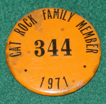
Brad Eckler remembers this area: I heard of your website and saw that you had an entry for Cat Rock in Weston. Our family were members for a year and it proved to be a convenient place to go. It was actually pretty steep for a 10 year old and not much of a run out. The rope tow was fast and seemed to go straight up then you flew down – and did it all over again. Fun Fun Fun! To the right is my membership pin from 1971. |
|
Brian Malone has some information on the tow's final operating years:
My name is Brian Malone and in 1978 I graduated from UMass Amherst and was hired by the town of Weston as the Assistant Recreation Director. We had a small Department with an even smaller budget. One of my first jobs was to work on the engines, string the tows ropes and check the pulleys at Cat Rock. I replaced some of the pulleys wheels, spliced the ropes and rewired the rope tows motors to meet new safety codes. I spent a lot of time up a Cat Rock that first year, a beautiful place.
We hired a staff but for the next two winters we never got Cat Rock into operation due to a lack of snow. Budget cutbacks, difficulty in hiring qualified trained staff and low daily ticket sale data from the mid 1970 forced us to closed the area in 1980. The winter of 1977 was the last year of operation but the area officially closed in 1980. We continued to mow the hill every year in hope that someday the program might be restored. I worked for the town until 1989.
Dana Dorsett skied this area in February 2001, here is his story:
With a foot & a half of heavy maritime blow in the driveway at home, it seemed like the right day to skip the usual noontime run in the Sudbury woods and actually _drive_ to skiing . Venue of choice: Cat Rock Park in Weston MA. It's been a couple of whiles since the T-bar ran, but the decently pitched open run has ~200' of vertical to play on, with hair-ball woods shots on all sides.
Arriving at 12:30 it was 40F+ and sweaty out. Eschewing the roads & trail to skin straight up the hill, the yelps & laughs from the N. aspect told us sight unseen that first tracks were unlikely. Clearing the lofty (?) summit in something like 3:27 minutes the it looked like we were luckier than at first thought!
On the lower 1/3 of the main trail a couple of beer & weed powered snowboarders were 80% through with their civil engineering project- a 6' high kicker with an equivalent landing zone ramp 20' downslope. They'd chewed up 1/2 the width of the trail with their snowballing tracks, but there was but a lone snowboard track from 2/3 of the way up, the rest was wide open & untracked save a short postholer track to skier's left near the summit.
That didn't last long! A handful of runs later there were still some relatively untracked lines, but the beginning telemarker I was with was sure taking them wide, leaving the occasional crater in the 10-12" of heavy unforgiving crud. For the finale' I ducked through a mountain biking trail for a bit of fun in much slower conditions under the trees. Mission accomplished, 15 minutes later we were back at work, refreshed, with smiles all around."
Ted Chan also still skis the area: My buddies and I still go up the Cat Rock sometimes or imbibement. For skiing, it has to snow at least foot or so really for it to be fun, but Cat Rock has just the right density for tree skiing and a couple sweet rock face drops down the back side. In 1998 there was a big Nor'easter and it dropped about a foot and a half and you could drop the faces pretty safely. You can see the skyline of the city of Boston about 10 miles away from the summit.
The following are pictures that Jed sent to us. I've scanned them in and here they are:
Cat Rock Photo Album
Base Area
| The ballast for the rope tow at the bottom of the slope. |
|
|
|
The old sign for the snack bar. |
| Looking at the slope from the bottom. The beginner area tow was on the left. |
|
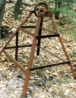
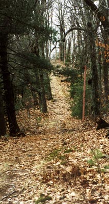
Rope Tow Lift
|
|
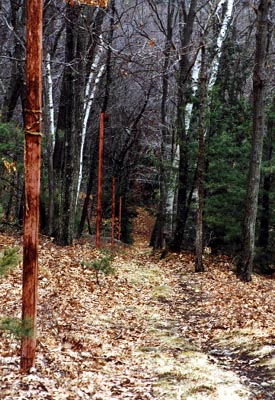
Looking up the rope tow line through the woods. |
| One of the towers for the rope tow. |
|
|
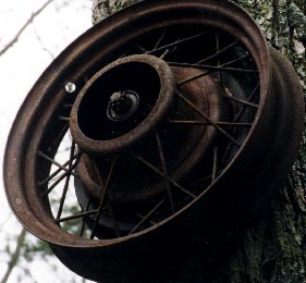
|
A close up of one of the wheels for the tow. |
| Looking down the same rope tow line through the woods, somewhat steep. |
|
|
|
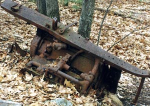
The old engine for the rope tow. |
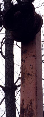
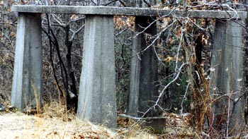
| The cement tower at the top of the slope, at the end of the rope tow. |
|
Summit
|
|
Looking down the slope at Cat Rock, quite a drop! You could go around the hemlock tree in the center of this photo. |
Last updated: Sep 8, 2010