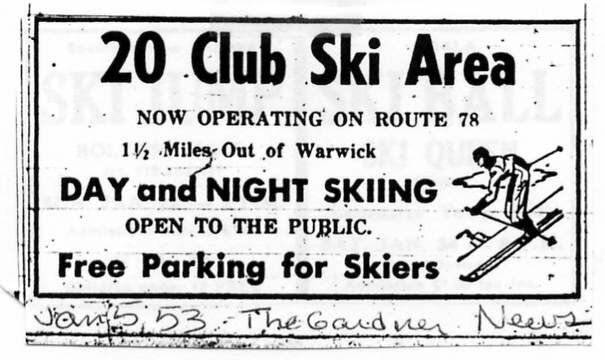
| Dick Kenyon found this ad from the Jan 5, 1953 edition of the Gardner News. The 20 Club Ski Area likely was the official name of skiing on Mt. Grace. The directions of 1.5 miles out of Warwick on Rte 78 match the location of Mt. Grace. |
|
Mt. Grace is an interesting lost area. Three NELSAP readers remember this area, but it does not appear in any print publications that a lift operated. However, a rope tow is still standing and trails are growing in. It was fairly small, likely 200' of vertical, with one tow.
Mt.
Grace was also the site of non-lift served skiing in the 1930's and 1940's, with
trails from the summit along with open slopes.
| Dick Kenyon found this ad from the Jan 5, 1953 edition of the Gardner News. The 20 Club Ski Area likely was the official name of skiing on Mt. Grace. The directions of 1.5 miles out of Warwick on Rte 78 match the location of Mt. Grace. |
|
Here are memories and more information from other readers:
Dana Dorsett-
On the
NNW corner of Mt. Grace, MA in Warwick, MA there's an abandoned ski area
with a nearly intact rope-tow (the motor drive and poles are there- it's
an old General Motors straight-6 gas powered thing.) There's at least
one ski trail that's still clear enough to take a run on, and it's got
some grade to it at the top (no headwall, to be sure.)
To find it, look at your hiking guides to find where the Metacomet-Menadnock trail crosses Route 78 north of Warwick. There's a parking for the trail heads into the State Forest. If you start toward the M-M trail and take the first trail left (right after you leave the parking lot) heading roughly south parallel to Rt. 78. The rope tow drive will be on your right within a couple hundred yards.
The ski trail parallel to the tow rises something like 50-75 whopping feet of vertical gaining pitch to a maximum of about 20-25 at the top. It looks like it may have extended further up the hill at one time, but I didn't have time to explore further for more trails or lifts. I _do_ intend to ski this trail (and the M-M from the summit of Mt. Grace) the next time there's sufficient snow.
Feb 2000-And he did! Here's an article by Dana about the skiing, including photos:
Skiing in a State of Grace Mt. Grace, Massachusetts
Presidents Day weekend, Saturday 7AM:It was snowing hard. The view from the window of the plow berm left by the frustrated rocket scientist (wasting his talent driving snowplow) made it clear that it would take 20 minutes just to drive out to the street, let alone make time on the trek up to Mt. Cardigan NH, since Jan had taken the SUV for the day.
The rock skis were at the ready, a pre-prepped pack waited with beacon, shovel & probe-poles on board at the prospect of skiing a few steeper lines on Cardigan. All dressed up, and nowhere to go...Aw heck, the avi-hazard was bound to be maxed out on the better stuff anyhow!
Hmmm...*&^%*&^.... what to do... Figuring messy driving would keep my buddy Sandy from driving up from Rhode Island to mix it up with hordes of school vacationers at the local Mt. Wachusett, lift-served yo-yos held negative appeal. And, as much new snow had fallen, the snow pack in the woods at Wachusett still was inadequate for skiing the ledgy bouldery back bowls...
Then, epiphany!In the flash of inspiration where the caffeine hits the sugar, transcendence, the sudden realization that I live in the State of Grace! (Mount Grace, Massachusetts, that is!)A quintessentially New England un-inspiring bump of a hill spittin’ distance from the NH border, Mt. Grace rises to a mere 1610’ above the Atlantic, but it’s blessed with skiable hiking trails and an abandoned ski area on it’s NE flank- an ideal consolation prize on a high-avalanche hazard day, if only I could con a buddy with a 4WD to go along.
I know, call Aaron- he’s easy, especially if backcountry skiing is involved!
At the
turnout just north of where the Metacomet Menadonock trail crosses route
78 Aaron gunned it to crash through the plow berm and spin-out facing the
road. Parked!
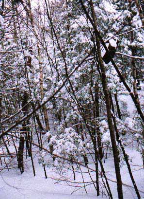
| A snowmachiner had beaten us to the punch on the hiking trails, making the quarter mile tour south on the Round the Mountain trail, to the abandoned ski area easier.The remains of the rope tow drive abuts the tracked up hiking trail. But the open lines on what remains of the ski trail was untracked!But not for long! This is skinnin’ & grinnin’ territory! | 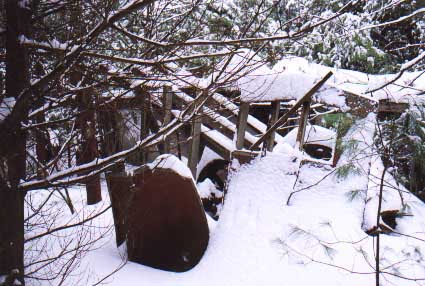
The remains of the rope tow drive. All photos courtesy of Dana Dorsett. |
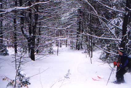
Starting
out fairly flat, the grade rises quickly to a sustained 15-20 degrees as
the line narrows.The open line ends almost 200 vertical feet above the
bottom, but picking our way though the denser trees we searched in vain
for skiable open glades or remnants of trail. heading toward the light,
I skinned/sidestepped below a 10’ granite boulder for a better view. With
one ski edged on granite & moss the other wedged between 2 small trees
on a sloughing 35 degree side hill I called back to Aaron, “Doesn’t look
like this is a ski trail!”He grabbed a tree to keep from falling from laughter.
|
|
Doubling back though a thicket of small hemlock & birch we caught glimpses of the lift cable in the branches and followed it as best we could in the quest for skiable trail. In the dense growth I nearly bonked my head on the top pole of the lift! We had found the top of the resort, but the lines immediately below weren’t exactly skiable- it was a real bushwhack!Turn, stop. push branches away, repeat... but shortly we were stopped atop the remaining open line, pausing to contemplate the dozen available turns. |
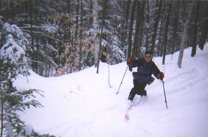
| Aaron took first tracks, bottoming out on a rain-crust every other turn in 8-12” of fluff.The remaining line varies in width from several yards, to several feet, with an average pitch as steep as a typical New England blue square trail, but more technical given the width and wild snow. Ducking the pungee-stick dead lower branches of the numerous spruce trees I took a slightly different line, gobbling up the 200’ vertical in short order. It is short sweet run, but has little room for error. (A bit of A “trail maintenance” may be in order.) But it was not unduly hazardous given the conditions. |
|
|
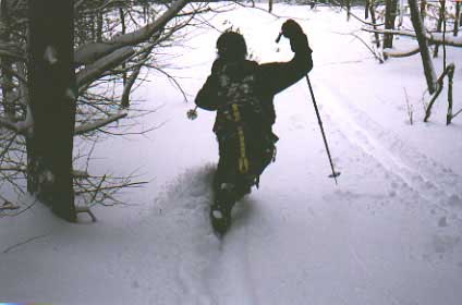 |
| Aaron heading down into the powder. | Dana ducking under the tree. |
Pressed for time, with much to do before dark, a short kick’n’glide later we were ready to blast back through the freshly reinforced plow berm back onto the highway.“I wonder how many runs at it we will have to make?” Aaron mused. (The answer: Seven! And the dealer always comments at trade in time on how well he takes car of his cars- if he only knew!)
All in all, for a short day trip, it wasn’t a bad consolation prize at all!
Brian O'Malley-
In Warwick
Ma. there's a good size mountain that had a ski area in the 70s called--MT
GRACE. This is on the ma/nh border.
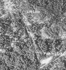
| Here's the Terraserver pic of this area...notice how grown in it is, and how hard it is to see anything. |
 |
|
|
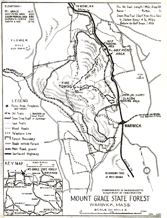
Bill Cobb provided this great trail map of the ski slopes in 1936, before the area added ski lifts. It was a hike up and ski down area at this time. |
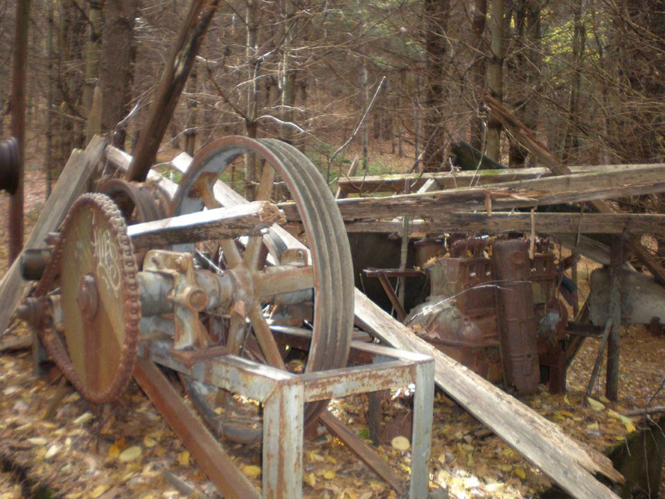
| John Mc hiked this area in October of 2009, and found the engine for the lift. He notes that " the large wheel in the foreground contains the words Dodge Mfg Co. Mishiwaka, Ind." Click on the image for the larger version. |
|
Has anybody else skied here before?
Page last updated October 14, 2009
Head back to Lost MA Ski Areas