(Mitch's Hockanum Ski Ranch)
Early - Mid 1950's
(Mitch's Hockanum Ski Ranch)
Early - Mid 1950's
| Thanks to Chris
Dixon, we now know about this lost area in Hadley! All of the
pictures/info of the area are his. Here are his details.
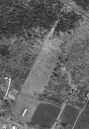
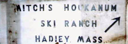
This one was called 'Mitch's Hockanum Ski Ranch' and was located at the base of Mt. Holyoke (the mountain itself, not to be confused with Mt. Holyoke College in S. Hadley MA a few miles away). The general area is known to old timers as the 'Hockanum Flats' section of Hadley, where the Mt. Holyoke Range dips down to meet the CT River (rising again to the west of the river and I-91 as the Mt. Tom Range). Hockanum was its own village a-way back when, and the former Hockanum one-room schoolhouse still stands as a historic strucure near the ski hill (there was also ferry service across the CT River from Hockanum to Northampton before a bridge went in to the north!). The ski hill is off of MA Rt 47, now called 'Hockanum Rd.' in this area. This slope has been a popular local sledding hill throughout the many years I have lived here (and I've skied it once or twice), but I always suspected it once had a ski lift because of a small shack at the bottom of a straight clear path which looks like a possible tow line. Lo and behold, on a recent closer inspection of the shack it definitely was a rope tow...and not only that, but a little onsite archaeology revealed a sign ID'ing the ski area by name (pic at top of this page) |
|
|
|
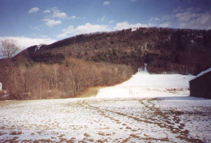
This pic is looking up
at the former ski area from the side of the road (Mass
Rt 47). I knew it as a sledding hill, but it was that little shack
by the trees at the lower left that originally got
me thinking that this may have been lift
serviced. The building at right is a tobacco barn.
Note the wide open slope with a narrower 'extension' above it. The rope tow unloaded about halfway up this upper section, as evidenced by two guide wheels mounted on trees (unfortunately, I'd run out of film by the time I noticed the wheels) As we can see, skiers would have been able to grab the rope at any point and ride up as steep as they wanted. At the top of Mt. Holyoke, approx above the lift shack, we see the historic Summit House of Skinner State Park (there is an auto road up, the start of which passes just uphill from the ski slope). The small cleared overlook on the ridge directly above the open slope has in years past been a popular (and sanctioned) spot for hang gliders to take off, eventually landing on the open slope. Hasn't happened much in recent years though so not sure if it's still allowed. The summit house is a good bit higher in elevation than the hang-gliding ledge, it just doesn't look like it from this angle! |
| "Mitch" was almost certainly Mitch Drozdal, who also established Mitch's Marina on the Ct River, which is still in operation just across the street and a couple of hundred yards north from the ski slope. Mr Drozdal passed away a few years ago and it should be noted that, happily, his family has been working with the Mass Dept of Environmental Managment to preserve much of his holdings in this historic and environmentally important area! Most of Mt Holyoke (incl. a historic summitt house) is officially Skinner State Park, and some Drozdal properties serve to connect the mountain parkland to a corridor of other protected lands along the CT river (not sure of the status of the former ski area itself, tho). |
|
|
|
One lifelong Hadleyite (my mechanic, who says he worked on the tow motors both here and at Tinker Hill) told me that he thought the Hockanum ski tow was in operation for just a few short years ca. the early-mid 50s. In fact, it was open so briefly that some other life long residents I've talked to don't even recall the area! Still, the physical evidence of an operational rope tow is undeniable. |
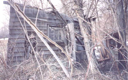
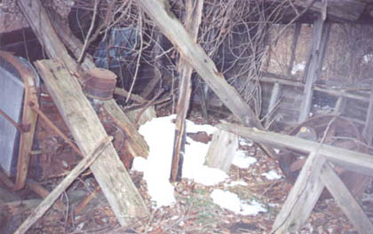
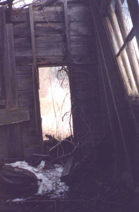
| This is from inside
the lift motor shack, looking out the rope exitway toward
the top of the hill.
|
|
|
|
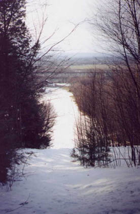
Finally,
here's a view downslope from the uppermost unload area of the rope tow.
Note the CT River right across the street!
|
If
you have more information on this area just let us know.